Earthwork optimization for complex sites is one of the most decisive factors in controlling grading cost, reducing design rework, and protecting project feasibility on difficult terrain. In large-scale developments, a grading solution may look technically compliant at first glance, yet still create costly friction later if roadway profile, pad elevations, drainage flow, and grading transitions are not working together. This is why AXANH treats grading as a strategic engineering decision rather than a drafting task.
For global partners, design firm leaders, and long-term collaborators, that difference matters. A site can meet design criteria on paper and still become expensive to build if the logic behind cut and fill balance is not resolved early across roadway profile, pad elevations, drainage flow, and grading transitions.
Why Earthwork Optimization Becomes a Cost Multiplier on Complex Sites
Managing earthwork optimization for complex sites is inherently difficult because natural slopes, elevation differences, drainage patterns, physical constraints, and access limitations all affect how efficiently a site can be graded. When grading strategy is poorly handled, the result is rarely confined to an earthwork report. It quickly becomes a cost problem, a coordination problem, and often a schedule problem.
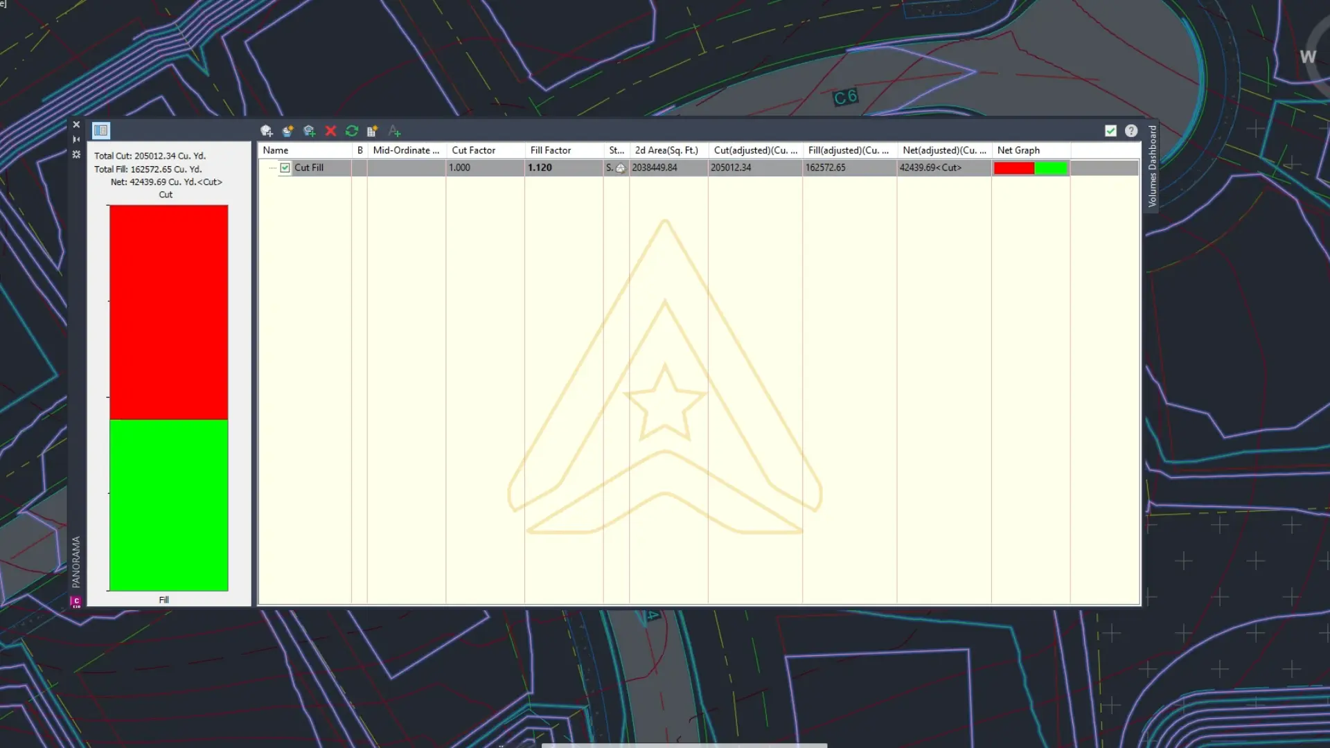
Excess cut increases hauling, disposal coordination, and site disturbance. Excess fill introduces more imported material, more trucking, and greater exposure to construction cost escalation. In either direction, poor cut and fill balance can change the commercial logic of the project.
The consequences do not stop there. A roadway profile that appears reasonable in isolation may later force difficult tie-ins, inefficient pad relationships, or grading breaks that are harder to construct than they are to draw. Once those conflicts emerge, teams often lose time revisiting elevations, transitions, and surface behavior across multiple design areas.
Drainage makes the challenge more critical. On uneven terrain, grading is never only about achieving the right final elevations. It must also support how water moves across the site, where it is collected, and whether the final surface will perform reliably over time.
Cut and Fill Balance Is an Engineering Trade-Off, Not Just a Quantity Target
Projects on difficult topography rarely struggle because engineers cannot calculate cut and fill. They struggle because cut and fill balance is often treated too narrowly, without fully considering alignment, profile, drainage, pad elevations, and constructability at the same time.
| Design Variable | What It Influences | Why It Matters |
|---|---|---|
| Roadway alignment | Corridor efficiency, grading conflict, tie-ins | A weak alignment can increase downstream grading complexity |
| Vertical profile | Compliance, drivability, earthwork balance | Small profile shifts can significantly change cost and constructability |
| Pad elevations | Drainage behavior, fill demand, site transitions | Pad decisions often affect the grading logic of the wider site |
| Restricted areas | Environmental impact, grading flexibility | Constraints reduce design freedom and magnify poor early choices |
A practical horizontal alignment should work with the site rather than against it. A vertical profile should satisfy design criteria while minimizing unnecessary differences between proposed surfaces and existing ground. Pad elevations should support drainage without creating avoidable fill demand. In restricted or environmentally sensitive zones, every one of these decisions carries greater weight.
The key insight is this: a grading design can be technically compliant and still be inefficient. On complex sites, stronger decisions come from understanding how alignment, profile, drainage, transitions, and earthwork quantities influence one another across the whole project.
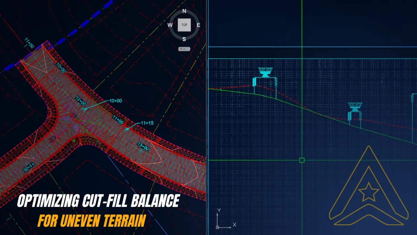
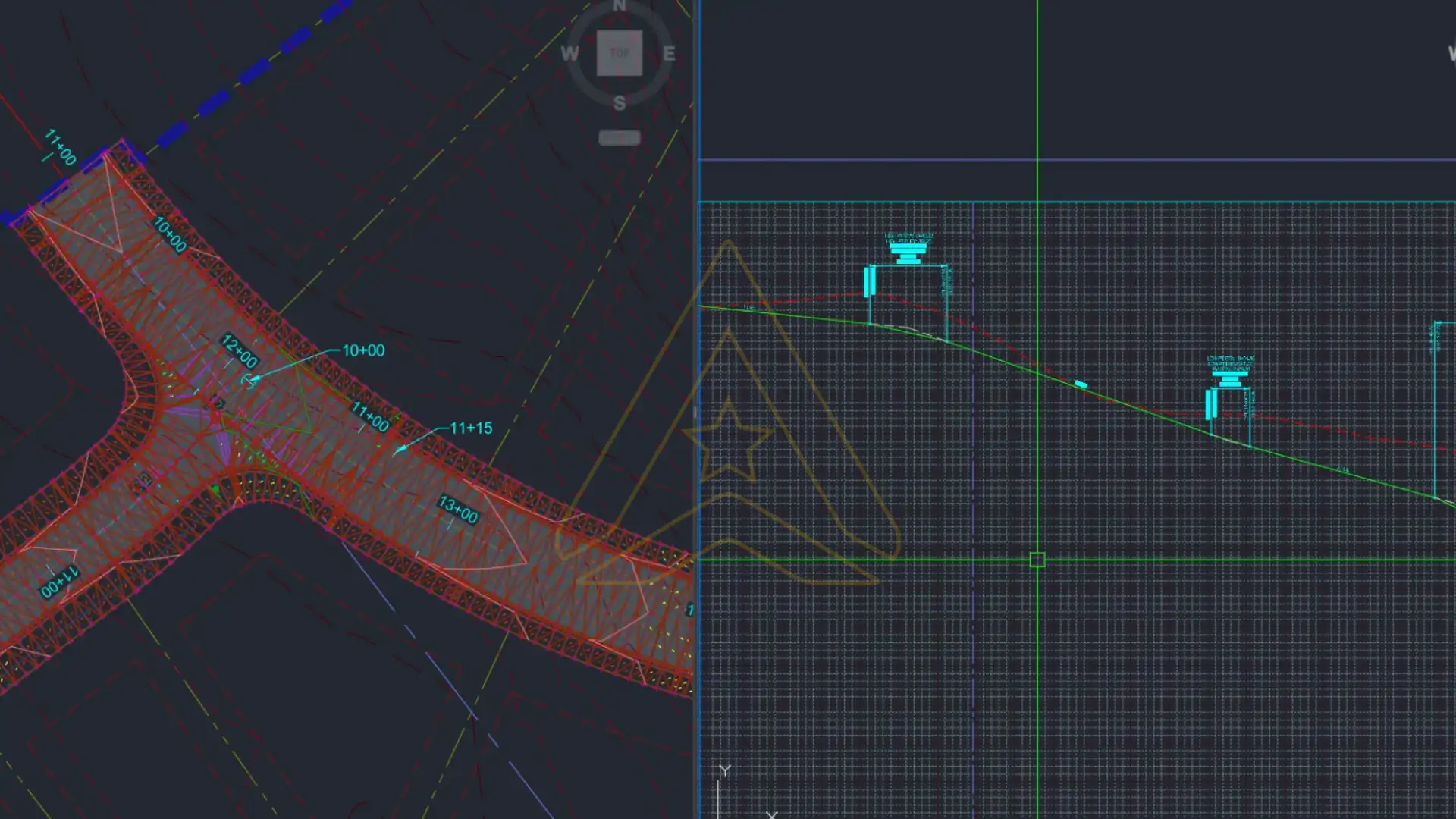
How Roadway Profile, Pad Elevations, and Drainage Shape Grading Efficiency
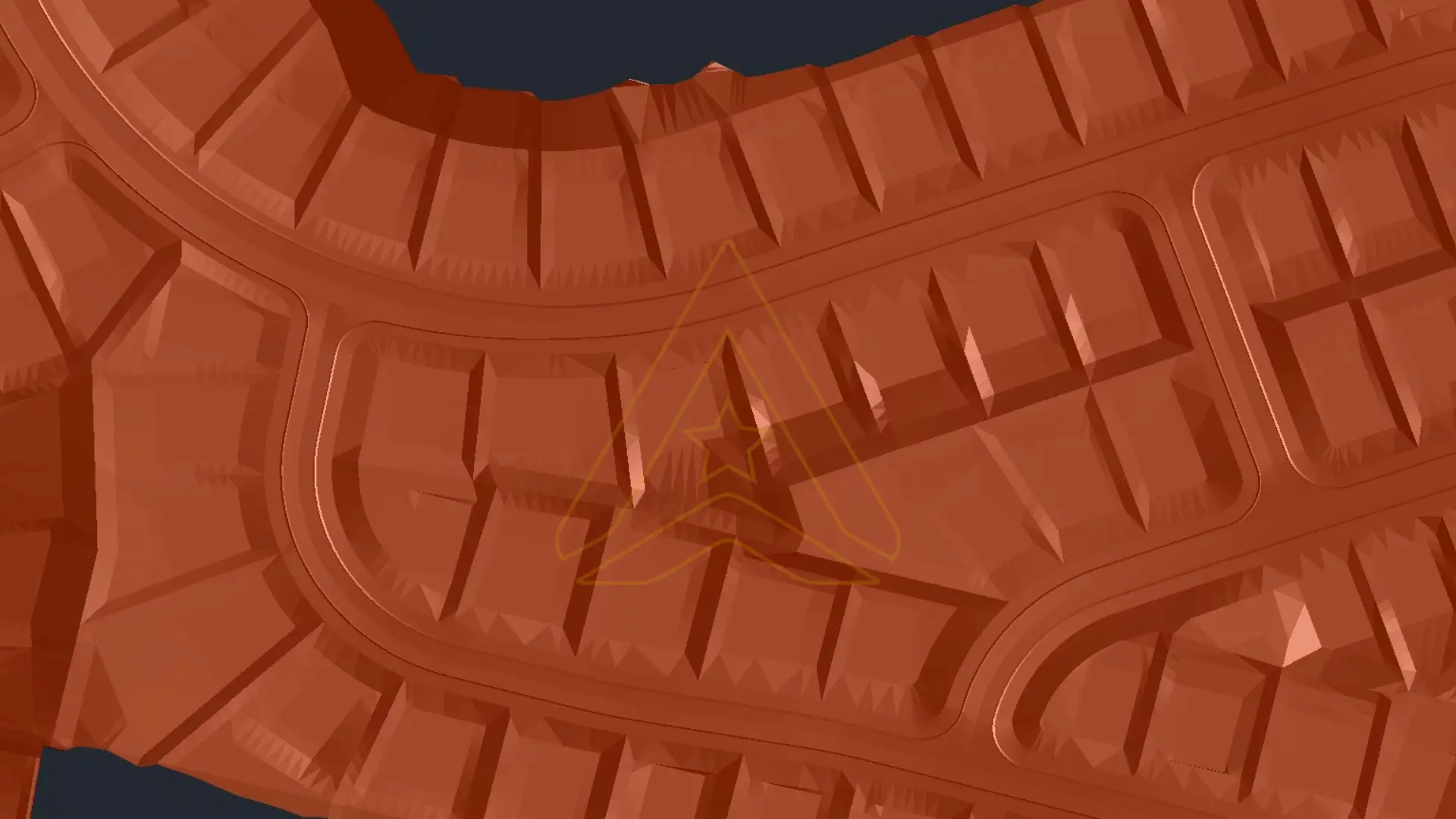
Site grading optimization works best when the design team studies the whole site as a connected system, not as separate surfaces or isolated quantities. Roadway geometry, pad elevations, drainage intent, and grading tie-ins must support one another from the early stages of design.
1. Establishing a practical roadway alignment early
At the early stage of a project, roadway alignment in plan view often determines how much grading pressure will appear later. AXANH studies site boundaries, existing access, physical constraints, and broader development logic so the corridor supports efficient grading rather than forcing unnecessary terrain conflict downstream.
2. Optimizing the vertical profile instead of tracing the terrain
Once the alignment is set, profile design becomes a major lever for earthwork cost control and constructability. AXANH treats the profile as an engineering optimization process, where slopes, vertical curves, smooth transitions, local criteria, and buildability are considered together. The goal is not to follow the terrain passively, but to shape a roadway that performs well while avoiding unnecessary earthwork.
3. Coordinating grading and drainage as one system
After roadway geometry is established, grading must extend across pads, functional zones, and all transition areas. Surface design is developed with drainage intent from the start so stormwater moves toward the right collection and discharge paths rather than creating ponding, erosion risk, or hidden long-term maintenance issues.
Where digital coordination is essential, Civil 3D modeling support for land development can help teams study how terrain, roadway geometry, and grading surfaces interact before those decisions harden into downstream rework.
How AXANH Approaches Site Grading Optimization Early in Design
Too many teams evaluate earthwork consequences too late. By the time cut and fill are reviewed seriously, the design may already be too rigid, too coordinated, or too far advanced to improve efficiently. That is when technically complete work can still reveal expensive flaws.
AXANH integrates quantity review into the design development process so the project can respond while key geometry is still flexible. Once a preliminary solution meets technical and regulatory requirements, the design is checked against earthwork expectations, grading behavior, drainage performance, and broader site feasibility. If the balance is not supporting project goals, the design is refined early rather than defended late.
- Refining roadway profile elevations to reduce unnecessary cut or fill
- Adjusting pad elevations to improve transitions and drainage performance
- Improving grading tie-ins between roadway and adjacent development areas
- Reducing surface disturbance in constrained or sensitive zones
- Rechecking stormwater behavior after each significant grading revision
This is where earthwork optimization for complex sites becomes more than a technical metric. It becomes a decision framework that helps teams protect cost efficiency, reduce rework, and maintain a more buildable path forward.
From Difficult Terrain to a More Buildable Land Development Outcome
In a typical complex-terrain scenario, achieving a practical cut and fill balance is not simply about fitting a roadway into existing topography. The deeper challenge is doing so without creating major grading breaks, unstable transitions, or earthwork imbalance that pushes construction cost upward.
AXANH addresses this kind of site by first identifying which alignment and profile decisions will have the greatest influence on the rest of the grading system. Instead of locking surfaces too early, the team uses existing conditions and client-provided data to test whether roadway geometry, adjacent pads, and site transitions are moving the design toward a practical and defensible result.
As the design develops, grading relationships are reviewed across roadway corridors, buildable pads, and key functional zones. Drainage paths are checked to ensure the surface performs as intended. If one area creates excessive cut, or if fill demand grows beyond acceptable thresholds, the design is refined before those issues spread into later coordination and documentation work.
The outcome is not just a better report. It is a better decision path. The project becomes easier to coordinate, easier to explain to stakeholders, and more likely to stay within a realistic cost envelope while remaining technically robust.
This is the practical value of stronger engineering judgment: fewer avoidable surprises, fewer late-stage revisions, and a design that performs more coherently across geometry, grading, drainage, and constructability.
Why Better Grading Decisions Matter to Global Design Partners
For international collaborators, design firm leaders, and strategic partners, the value of stronger earthwork optimization extends far beyond one deliverable. A partner who understands terrain behavior, roadway geometry, drainage intent, and earthwork balance can reduce pressure on the lead team and improve decision quality across the project.
- Lower rework risk: better grading logic reduces the chance of major redesign later
- Stronger coordination: roadway, grading, and drainage work more coherently together
- Better project confidence: balanced and buildable solutions are easier to advance toward approval and construction
- More valuable digital delivery: modeling supports decisions instead of merely accelerating production
For broader land and infrastructure packages, integrated land development design support can also help translate difficult terrain into clearer development outcomes.
What Stronger Earthwork Optimization Requires
On complex sites, stronger outcomes usually depend on four capabilities working together: a realistic understanding of topographic constraints, the ability to shape roadway alignment and profile with long-range grading consequences in mind, integrated thinking across grading and drainage, and a disciplined review process that uses quantity feedback to refine the design before rework multiplies.
That is where AXANH creates value for long-term collaborators. The goal is not only to complete grading tasks, but to help global partners move from existing conditions to a clearer, more construction-ready solution with less avoidable friction.
Earthwork optimization for complex sites is ultimately about making better decisions earlier. When alignment, profile, drainage, transitions, and earthwork quantities are studied as one coordinated system, projects become easier to develop, more efficient to build, and less vulnerable to costly redesign.

Need a Smarter Path Through Complex Terrain?
When uneven topography begins to put pressure on earthwork cost, grading efficiency, drainage coordination, and design timelines, better earthwork optimization can change the direction of the project.
Frequently Asked Questions
What is earthwork optimization in land development?
Earthwork optimization is the process of refining grading, cut and fill quantities, roadway profiles, pad elevations, and drainage behavior so a site can be developed with less unnecessary excavation, import, export, and redesign.
Why is cut and fill balance important on complex sites?
Cut and fill balance helps reduce hauling, imported material, disposal needs, and grading rework. On complex terrain, it also affects drainage, constructability, and overall project feasibility.
How does roadway profile design affect earthwork cost?
Small changes in vertical profile can significantly affect the amount of cut or fill required. A better profile can reduce grading conflict while still meeting technical standards, local design criteria, and drainage requirements.
How does Civil 3D support grading optimization?
Civil 3D and model-based grading workflows help teams evaluate surface behavior, drainage slopes, grading constraints, and cut and fill outcomes before design decisions become difficult to change.
When should cut and fill analysis begin?
Cut and fill analysis should begin during early design development, not only at final quantity reporting. Early quantity feedback allows teams to adjust alignment, profile, pad elevations, and drainage strategy while the design is still flexible.