



Partnership Models
Partnership Fit
Strategic Partnerships
Why AXANH
Discuss Your Needs




STA 0+00 · PROJECT
Land development · End-to-end digital delivery
Marks Creek Development: 376 lots on 101 wooded acres, designed end to end in 3D.
A 101-acre wooded site, 376 residential lots and a large electrical transmission network running through it. Elevations ranged from 300 to 350 feet above mean sea level, with ponds, streams, wetlands and buffers across the property. AXANH supported the project from conceptual design through approval, with the work delivered digitally using BIM from start to finish.
High density, community appeal, lower construction cost and strong lot value: the design had to serve all four at once.
101acres
376lots
300–350 ftelevation range
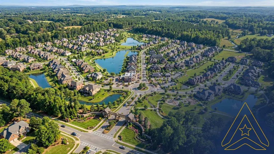
MARKS CREEK · 101 ACRES · 376 LOTS
STA 1+00The site
The site
Wooded, wet and crossed by power lines
Four conditions made the geometry harder than the lot count suggests.
01
Steep, varied terrain
Elevations from 300 to 350 feet above mean sea level, with grades that changed across the site and complicated every road and lot.
02
Water, wetlands and buffers
Ponds, streams, wetlands and buffer zones were part of the land, and environmental regulations and permitting set firm limits on the design.
03
A transmission network on site
A large electrical transmission network crossed the property, which called for safety clearances and protective measures planned into the layout.
04
Intersections with real constraints
Numerous complex intersections carried elevation differences and house-spacing requirements, so road geometry and lot layout had to be solved together.
STA 2+00The decisions
The decisions
One model, three design decisions
Everything below was built in a single connected model, so a change in one place showed up everywhere.
D1
Model the land first
Complex topography and natural features were modeled before roads were drawn, giving the road network and the preliminary road design an accurate, shared base.
D2
Balance the earth
Grading and earthwork were optimized to balance excavation and fill, and a stormwater drainage network was designed on top of those finished surfaces.
D3
Plan the lines and distances
Utility layouts were modeled to meet separation requirements, and the clearances and easement limits around the transmission network were built into the layout so utilities and power lines coexist.
STA 3+00AXANH’s role
AXANH’s role
What AXANH designed
From the first concept to the plans submitted for approval, delivered in a digital workflow.
WHAT WE DESIGNED
Conceptual designs and detailed plans. Preliminary road design and earthwork volume analysis. Design surfaces balancing excavation and fill. A stormwater drainage network. Utility layouts that meet separation requirements. Clearance and easement planning around the transmission network.
ONE PLATFORM FOR EVERYONE
Stakeholders worked from a shared project platform, with Autodesk Construction Cloud as the common environment. Everyone worked from the current model, so a change made once reached every sheet and every reviewer.
- Autodesk Civil 3D
- Autodesk InfraWorks
- Autodesk Storm and Sanitary Analysis
- Vehicle Tracking
- Dynamo
- Autodesk Construction Cloud
STA 4+00What it shows
What it shows
What this project says about working with AXANH
01
BIM from the first sketch
Starting in 3D means terrain, roads, grading and utilities are checked against each other from the earliest concept, not at the end.
02
Constraints as design inputs
Transmission clearances, wetlands and house spacing went into the model as rules, so the design respected them from the start.
03
A shared model, shared decisions
When engineers and stakeholders work from one platform, a question gets answered once and the answer reaches everyone on the project.
More projects
MORE
Mitchell Mill Development
A 142-acre, 382-lot community in Wake County, North Carolina: roadway profiles, retaining walls and swales on steep ground.
MORE
Baptist Development
A 600-acre, 777-lot development with flood-prone areas, stream buffers and a transmission network, delivered in three stages.
MORE
Robertson Development
A 200-acre, 644-lot community with rolling terrain and a distant sewer connection, produced under the client’s Professional Engineers.
STA 5+00Start the conversation
Next step
Have a wooded, constrained site that needs a clear digital plan?
Share the terrain, the regulations and the timeline. We will show you how AXANH would set up the model and the first package.